Advanced Lidar Applications
Measure turbulence and shear across entire wind farms? No problem!
Meventus’ expertise in utilizing high precision lidar systems for wind regime assessment provides you with better accuracy in turbine load predictions


Better Predictions
Innovative Applications
High Resolution Lidar Systems

Advanced Lidar Applications
Through our innovative application of new lidar systems, Meventus has developed methodologies to better predict wind loading in highly complex or forested terrain. Using our methods, we can predict turbine loading and maintenance needs in the pre-construction phase with much higher accuracy.
Traditional wind resource assessments are typically based on wind data from one single met mast and extrapolated across the site using simple RANS-based flow models.

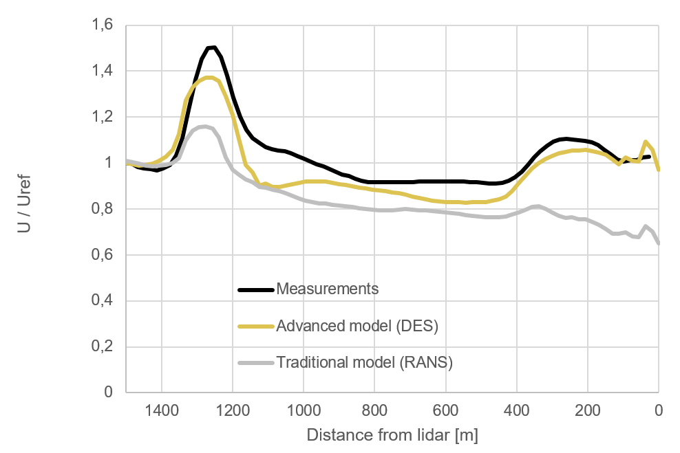
Our approach uses lidar systems with high spatial and temporal resolution in combination with advanced DES flow models. By using the lidar measurements along a line-of-sight for validation of the flow model, the number of validation points increases from one (using a traditional approach) to several hundred (using the Meventus approach). This increases the accuracy of the flow models significantly.

Using advanced flow models, we are capable of describing the physics of large scale turbulence in complex and forested terrain.
We can document the accuracy of the models, and use the models to predict wind loading on turbines across entire wind farms.
The accuracy of the advanced models we use is superior to traditional RANS models that use crude approximations to model turbulent structures. These tend to fail in highly complex and forested terrain.

Our novel approach to model validation is only possible using high resolution lidar systems, capable of measuring small scale turbulence structures at distances several kilometers away.
Our system is capable of measuring at 2000 meters distance at 1Hz with spatial resolution of 12-18 meters. On distances shorter than 1000 meters, spatial and temporal resolution can be reduced to 9 meters at 10 Hz.

Meventus –
Would you like to work with us?
If you have an upcoming project in wind and you think we can help you,
please feel free to contact us, we’ll get back to you as soon as possible.


